
Dispatch Mapping Systems and Slippy Maps
Why Dispatch Needs Mapping
GPS coordinates themselves are conventionally expressed in WGS84 (World Geodetic System 1984), the standard geographic coordinate reference system GPS itself uses and that virtually all consumer/commercial mapping platforms expect as their input format — a useful thing to know when troubleshooting a location that "looks wrong" on a map, since a coordinate pair interpreted under the wrong reference system (a rare but real GIS pitfall) can place a point noticeably off from its true location.
Slippy Maps (Tiled Web Maps)
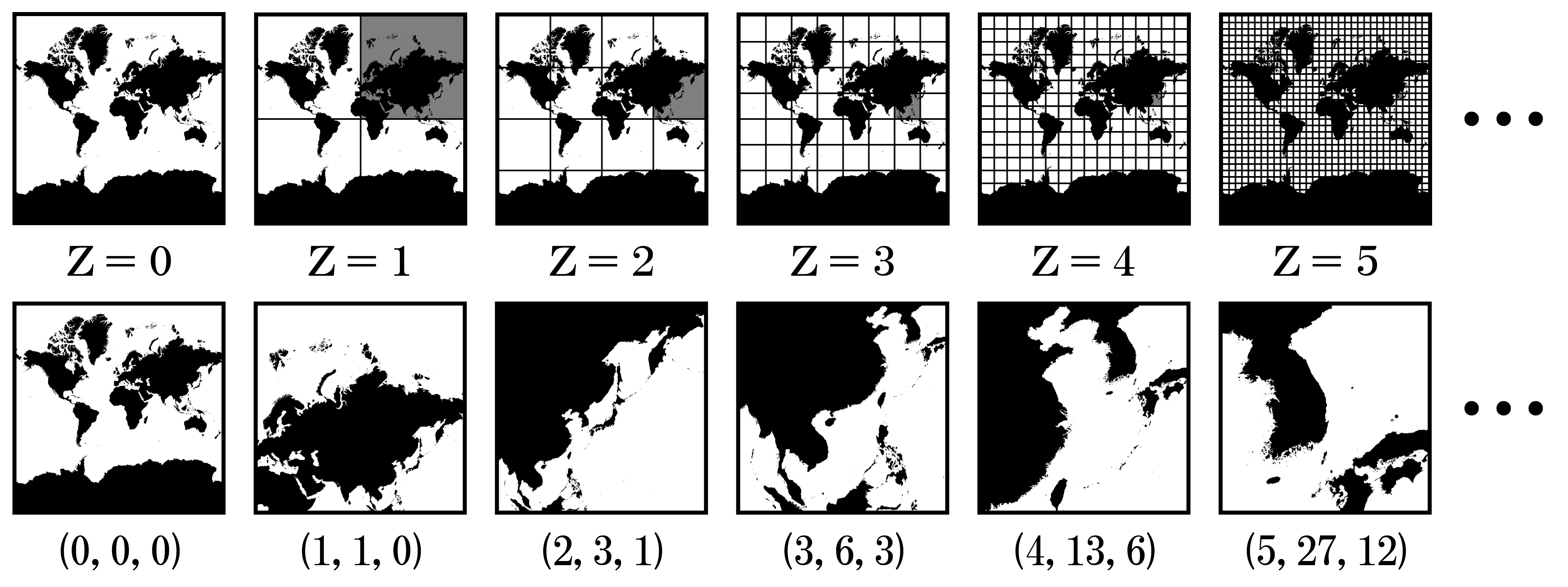
The interactive, pannable/zoomable maps used by virtually all modern dispatch mapping systems (and web maps generally) are technically called tiled web maps, nicknamed "slippy maps" in the OpenStreetMap community for how smoothly they pan and zoom. Rather than loading one enormous image, a slippy map loads many small square tiles, each fetched from a URL pattern like .../{z}/{x}/{y}.png, where z is the zoom level and x/y identify the tile's position at that zoom level. Each zoom level doubles the tile grid in both directions, and a JavaScript component in the browser fetches only the tiles currently visible, in the background, without reloading the whole page — replacing older approaches like Web Map Service (WMS), which served a single large static image with simple pan-arrow navigation.
Raster Tiles vs. Vector Tiles
Not all slippy-map tiles work the same way underneath, and the distinction matters for both appearance and performance:
- Raster tiles — the original/classic approach: each tile is a pre-rendered image (PNG/JPG) generated on the server ahead of time with a fixed style baked in. Simple for the client (just displays images) but every zoom level and every style variant needs its own complete set of pre-rendered tiles, and the map can't be restyled, rotated, or tilted on the fly without fetching a whole different tile set.
- Vector tiles — the more modern approach (the de facto format is "Mapbox Vector Tiles," commonly with a
.mvtor.pbffile extension): each tile carries raw geometry/feature data rather than a finished image, and the client (typically using a library like Mapbox GL JS or the open-source MapLibre) renders and styles it locally. This makes vector tiles smaller to transfer, lets the same tile data support smooth zoom/rotate/tilt interactions and dynamic restyling (e.g., a "dark mode" map) without re-fetching different tiles, and is the technology underlying modern GL-based mapping SDKs.
Common Misunderstandings
- "The map itself contains the live vehicle positions" — it doesn't; the base map (whether raster or vector tiles) is essentially static reference data (roads, terrain, labels), refreshed on its own schedule by the map provider. Live AVL/unit positions are a completely separate, independently-updating data layer drawn on top of the base map — a stale or wrong-looking base map (old road data, a business that's moved) is a mapping-data issue, while a wrong-looking vehicle position is a GPS/AVL data issue; they're diagnosed completely differently. See GPS for the location-reporting side of that distinction.
Troubleshooting Implications
- Coordinates plot in a plausible-looking but wrong location — beyond an outright GPS accuracy problem (see GPS), confirm the coordinate reference system assumption (WGS84 vs. some other datum) matches between whatever produced the coordinates and whatever's plotting them, especially when integrating with an older or specialized GIS data source that might not default to WGS84.
Related Pages
References
See also: CTI product documentation
This article is part of the CTI Products Knowledge Base. Questions about RadioPro or MCN products? Call +1 (513) 595-5900 or email info@ctiproducts.com.
Informational only. This article is general background and is not engineering, safety, legal or regulatory advice. Verify requirements with the equipment manufacturer and the applicable authority before relying on it. Product names and trademarks belong to their respective owners.